Alabama Wall Map
Beschreibung:
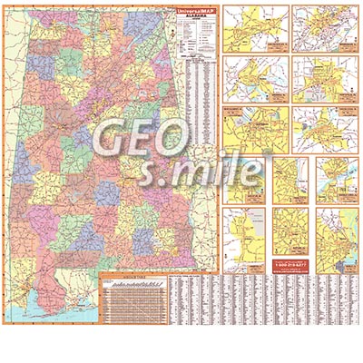
Wall Map by Universal Map measures 58" x 54" and shows
all of Alabama in complete street detail with the boundaries
as follows: The entire state of Alabama with color-coded counties
and inset maps of Anniston, Huntsville, Auburn/Opelika, Mobile,
Birmingham, Montgomery, Decatur, Phenix City, Dothan, Shoals Area,
Gadsen, and Tuscaloosa.
Special features and data contained on this map are as follows:
all state and federal highways, major waterways, towns,
military installations, exit numbers, an index to counties
and county seats, major airports, the state university,
various points of interest, time zone boundaries, cities,
state parks, wildlife areas, a mileage table,
and a city-town-place index.
Unsere unschlagbare Preis-Politik:
Beste Qualität zum günstigsten Preis!
Bestellformular Download
Was ist eine Echtholzbestäbung?
Was ist ein Springroller?
Verfügbare Versionen:
Alabama Wall Map - laminated, with rods
(Artikel-Nr.: 100002199)
(Artikel-Nr.: 100002199)
USD 219,00
