XXL Advanced World/USA phys.
(Combo) (Wenschow)
Ausschnitt 1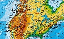
|
Ausschnitt 2
|
Ausschnitt 3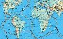
|
Ausschnitt 4
|
Ausschnitt 5
|
Ausschnitt 6
|
Beschreibung:
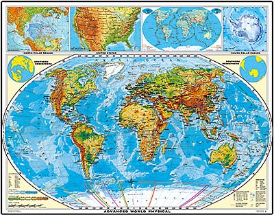
Advanced world with plate tectonic inset map / United States physical - (Combo)
Map Information:
Physical Map World
Please note:
On Wenschow maps we will add 8% shipping and handling.
Advanced world with plate tectonic inset map / United States physical - (Combo)
Map Information:
Physical Map World
- Employs Winkel projection (Winkel projection recently adopted by National Geographic as the most accurate world map projection)
- Easy to locate places and determine the position
- Introduces land elevation with 7 glowing colors to display land relief
- Depicts ocean depth with 5 colors to display ocean relief
- Includes warm and cold ocean currents
- Illustrates physical and political characteristics
- Remarkably effective with outstanding long-distance effects
- Displays North and South Polar Region on panel
- Displays plate tectonic map on panel
- Features advanced legend
- Plastic lamination (tear-free) for protection on both sides, reflection-free
- Markable and washable
- Employs Lambert azimuthal projection
- Introduces land elevation with 7 glowing colors
- Depicts ocean depth with 5 colors
- Features world locator map
- Displays Alaskan and Hawaiian island change
- Displays US time zones
- Illustrates physical and political characteristics
- Features advance legend, grid, compass rose
- Plastic lamination (tear-free)for protection on both sides, reflection-free
- Markable and washable
Please note:
On Wenschow maps we will add 8% shipping and handling.
Unsere unschlagbare Preis-Politik:
Beste Qualität zum günstigsten Preis!
Bestellformular Download
Was ist eine Echtholzbestäbung?
Was ist ein Springroller?
| Höhe: | 145 cm |
| Breite: | 180 cm |
Verfügbare Versionen:
XXL Advanced World/USA phys.
(Combo) (Wenschow) - Two maps mounted on spring roller with Backboard, laminated (Combo) Two maps mounted on spring roller with metal backboard (Combo)
(Artikel-Nr.: 100047674)
(Combo) (Wenschow) - Two maps mounted on spring roller with Backboard, laminated (Combo) Two maps mounted on spring roller with metal backboard (Combo)
(Artikel-Nr.: 100047674)
USD 299,00
